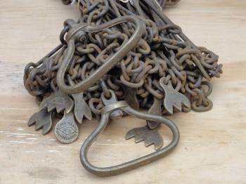
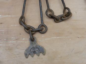
20th. c. Chesterman 100ft imperial chain.I bought this chain on an on-line auction site in 2010. I wanted to have an imperial one to use it for educational purposes next to the metric one and steel tapes in my collection. The chain was made by Chesterman, Sheffield, England and is in very good shape. Dating a chain like this one is quite difficult as the factory used the same logo for more than a century. A trade catalogue from 1962 still lists this very chain, but than only the 50ft tally shows their logo, while on this example the logo can also be found on the 40/60ft tally.1 The chain The chain is made of steel, 100 feet (30.48 metres) in length and made of 1 feet links. The links are joined together with sets of three rings per link, every tenth of which is has a bronze tally suspended from it at a fourth ring (see fig.5). The tallies have points indicating the number of 10 feet from each handle, while the centre tally is round (see fig.2). Both the centre tally and the 40/60ft tally have the trademark stamped in (see fig.4). The handles do not have a groove for the ground pins as is usual with other manufacturer's chains and steel tapes, like the ones by Tibaut Desimpelaere.3 The indication of the length, "100FT", is stamped into them and includes the handles completely at both ends.1 Use and diffusion The chain is one of the longest-in-use instruments in surveying. The first mention and depiction of a survey chain - or at the time so called "wyer line" - dates from 1590 and can be found in the work A Treatise Named Lucar Solace by Cyprian Lucar.4 Although the use of chains seized in the 1960s in the 'Western World', the chain is still in continual use outside it. An Indian textbook on surveying that was first published in 1999 still spends a paragraph and two pages with drawings on the chain. The author wrote that "Chains are used to measure distances when very great precision is not required. In our country [India] it is frequently used though in other countries it is being gradually replaced by tapes. [...] In India link type surveying chains of 30m lengths are frequently used in land measurement.".5 The textbook was written "...to be an introductory text for the first course in surveying for the engineering students ... of civil, architecture and mining engineering ... [and] ... will also be suitable for professional courses in surveying.".6  Figure 3: The handles of the chain are attached to shorter links and are included in the overall length. Chains have been made in imperial (like the Chesterfield one in my collection) and metric units. A set of 11 or 6 ground pins would have been used with the chain to count the sections measured with it. The fore man would have all pins at the start of the measurement, pushing one in the ground every whole length of the chain. The rear man would pick up the pins as they go. As soon as the fore man had no pins left, both men came together to exchange pins and they knew that another section of 10 or 5 chain lengths had been measured.7 Accuracy Although seemingly simple instruments, chains could produce very accurate results and were preferred above angle measurement devices up to the 18th century.8 In 1810 Nesbit wrote his first edition of a textbook on surveying, which would be continuously updated and reprinted well into the 20th century. The first edition did not contain any reference to the theodolite, which he explained in the 1820 second edition by stating that "As the theodolites is sometimes used in surveying Meres, Woods, Roads, Rivers, and Canals, when angles cannot be taken by the Chain, I have given a description of this instrument; but as neither it nor the Plane Table are ever used by Professional Surveyors, when they can avoid it; and as this Treatise is confined chiefly to Chain surveying, I have not given any directions for measuring either with the Plane Table or the Theodolite. Besides, the expense of these instruments places them out of reach of a great number of those persons...".9 A year later a chain by Throughton was used to measure a two mile stretch over ice. The measurement was repeated and found to be within one inch of the first result, which is a repeatability of 1:127,000 or 8mm/km!10 As indicated above chains were gradually replaced by steel tapes, like the ones by Tibaut Desimpelaere and Ahrend in my collection. Notes[1]: Chesterman, James Chesterman and Company Limited, Bow Works, Ecclesall Road, Sheffield II, England, Manufacturers since 1821 of Measuring Tapes, Rules, Gauges, Engineer's Tools, Catalogue No. 103, July, 1962, (Sheffield, 1962), p.B15.[2]: Idem, p.iii. Inscription on a Plate on the old "Bow Works" taken from The Descendants of John Chesterman. [3]: The catalogue in footnote one does not show any chain or tape with these grooves in their handles. [4]: A.W. Richeson, English Land Measuring to 1800, Instruments and Practice, (Cambridge (MA), London, 1966), p.77, 80. On page 77 Richeson accidentally dated this work 1690, where it should be 1590. [5]: S.K. Roy, Fundamentals of Surveying, (New Delhi, 2004), pp.30-32. [6]: Idem, rear cover. [7]: J.A. Muller, A. Scheffer, Landmeten en Waterpassen, Leerboek ten dienste van het Middelbaar Technische Onderwijs en voor zelfstudie., (Haarlem, Antwerpen, Djakarta, 1954), p.101. [8]: J. Morgenster, J.H. Knoop, Werkdadige Meetkonst, Tonende Klaar en beknopt, hoe dat al 't gene een Ingenieur en Landmeter te meten voorvallen kan, wiskonstig met en zonder Hoekmeting, door de minste moeite gemeten word; Hier by is gevoegt Een Verhandeling van Roeden en Landmaten in de voornaamste Plaatzen van de Seven Vereenigde Provincien, en eenige andere daar omtrent leggende Plaatzen, gebruikelyk., (Leeuwarden, 1744), p.190. [9]: A. Nesbit, A Complete Treatise on Practical Land-Surveying, In Seven Parts: Designed chiefly for the use of Schools and Private Students... The whole illustrated by two hundred and fifty Practical Examples, one hundred and sixty Wood Cuts, twelfe Copperplates, and an Engraved Field-Book of sixteen pages., (York, 1820), p.x. [10]: W. Bald, 'An Account on a Trigonometrical Survey of Mayo, one of the Maritime Counties of Ireland.', in: The Transactions of the Royal Irish Academy, Vol. XIV., (Dublin, 1825), pp.51-60. With many thanks to John Bradley for sharing this information. If you have any questions and/or remarks please let me know. |
Surveyor's crosses... Geodetic Sextants... Theodolites... Total Stations... Levels... Standards... Tools... Firms...
1953 Wild K2 Alidade 19th c. measuring rod 19th c. Lerebours chain 20th c. Ahrend chain 20th c. Chesterman chain 20th c. Tibaut steel tape 20th c. Ahrend steel tape 20th c. Ahrend steel tape 1980s DOSbouw clinometer


![Chesterman's trademark; a bow with the initials J[ames] C[hesterman] and 'CHESTERMAN SHEFFIELD'.](../pages/images/20th_century_chesterman_imperial_chain_20140301092616c.jpg)
